Channel Islands 3: Santa Rosa Island's Varied Landscapes

By Charleen - December 11, 2023

Just off the coast of southern California lies a series of 8 small islands, five of which form the Channel Islands National Park. On the third day of our Lindblad Nat Geo Venture cruise, we spent the entire day exploring the highlands, beaches, canyons and Torrey pine groves of Santa Rosa Island. An unexpected wealth of small wildflowers, glimpses of the elusive Santa Rosa Island fox and an old one-room school house rounded out our hike. And we even got back in time for me to head back out on one of the last zodiac raft tours. 

Santa Rosa Torrey Pine grove where we stopped for lunch
Water Canyon
Coastal Road, west of Black Rock
Bechers Bay, Skunk Point and Santa Cruz Island across the channel
View of Bechers Bay and Nat Geo Venture in distance from Torrey Pines Loop Trail
Santa Rosa coast north of Corral Point

Click here for Los Angeles Area Eats and Hikes.
Click here for Day 1. Embarkation, Dolphins & Moonrise
Click here for Day 2a.  Anacapa Island Cliffs & Wildlife
Click here for Day 2b. Santa Cruz Island Fox & Hike
Click here for Day 4. Santa Catalina Two Harbors & Avalon


We awoke to another stunning sunrise, this time at the rear of the ship over Santa Cruz Island. This allowed us to enjoy morning yoga while watching common dolphins trailing in the wake.
Sunrise behind as we cruised from Santa Cruz Island to Santa Rosa Island
A tasty smoothie was served during yoga, after which I enjoyed breakfast from the made-to-order omelet bar. 
As before, we were offered a choice of short and medium hikes that could be combined with zodiac raft trips in the morning or afternoon, or a long hike with a bagged lunch. The shorter hikes explored the historic ranching area and nearby Coastal Trail and the medium hike additionally incorporated the Cherry Canyon loop.  The long hike was to see the Torrey Pines, as Santa Rosa Island has one of only two groves of Torrey Pines in the world. 

From Arlington Springs Man to NPS Passport Station 

After returning from the Zodiac trip around the tip of East Anacapa the day before, we had learned about the discovery of Arlington Springs man on Santa Rosa, the oldest known human inhabitant of North America. Due to the fact that there are no burrowing animals on this mixed sedimentary and volcanic island, archeological sites are very well preserved. Discovery of 13,000 year old human remains that predate the disappearance of the pygmy mammoths from the island emphasized that there were likely multiple routes of migration for the first Americans. 

The island also had a rich ranching past, complete with a tiny one-room schoolhouse where the "youngsters of the workers there, like the Smiths and the Lopezes and the Gomezes" studied from around 8 am to 3:30 pm. I was particularly interested in this schoolhouse, for I had been told I could find an NPS Passport Cancellation Station inside.
Small white schoolhouse in historic ranch area
But as we had a long hike ahead of us to reach the Santa Rosa grove of Torrey Pines, I would have to wait until the end of the hike to discover if the station was open

Stunning landscapes and subtle wildflowers

After breakfast, we were on the first Zodiac raft out to the Santa Rosa Pier near the northwest anchorage of Bechers Bay. Upon arrival, we were greeted by seagulls perched on the railing posts of the pier...  a larger brown bird among them.
Clockwise: Osprey & gulls, dock, Santa Rosa sign, collapsed section of sedimentary layers
It turned out to be an osprey and we were treated to a display of different wing beat patterns as the osprey and closest seagull took flight simultaneously towards the horizontal striations of the beach cliff. A recent landslide further emphasized the sedimentary layers that were laid over darker bedrock. 

We commenced the hike by cutting through the old sheep ranch, making a stop at a restroom located near the junction of Soledad Road and Coastal Road.
Coastal Road 
While waiting for the rest of the group, we were treated to our first glimpse of a Santa Rosa Island Fox. This subspecies must be a bit more shy than the Santa Cruz fox, as it did not hold still for photographs. It moved through the tall, dry grasses, occasionally flicking its tail up to be seen.
Junction of Coastal Road and Soledad Road, where we saw the first of two foxes
As we walked along the Coastal Road, we were treated to a more wild flowers in bloom than I was expecting for November -- even in California. 
Heading southeast on Coastal Road
There were many examples of the state flower, beautiful bright yellow-orange blooms of California Poppy, sometimes interspersed with similarly sized white trumpets of the endemic Island Morning Glory.
California golden poppy
Continuing along the dusty road, we went pass the little airstrip. While the Toyan berries on Santa Cruz island had still been green, Santa Rosa's Toyans sported red-orange berries.
Toyan bushes near airstrip, with view of anchored Nat Geo Venture
After reaching the end of the pretty short airstrip, the road descended sharply down to the bottom of Water Canyon where we had to walk over planks balanced on rocks.
Crossing Water Canyon
Water Canyon
This was a beautiful area, with numerous gullies winding their way out towards the sandy Water Canyon Beach.
Gully allowing a glimpse of Water Canyon Beach along Bechers Bay
Lots of fox prints and scat lined the dirt road. Apparently these island foxes are not only elusive, but have a sense of humor. 
Look where the fox decided to leave a deposit
Just past the Water Canyon area, I found the skeleton of a rather large bird with a dark feather. It could certainly be a raven as we heard their calls.
Possibly a raven skeleton
There were small, delicate daisy like flowers growing among what looked like dry sticks, and one or two examples of the familiar red Indian Paintbrush. Up on the shrubs, there were many feathery blooms, with stalks of buckwheat, this time with red blooms below.
As the road wound along, beautiful views of Bechers Bay beckoned the eye, with Santa Cruz Island across the channel.

Presently we passed signs for a short spur trail out to Black Rock (which we could not see)

The Torrey Pines Loop Trail branches off of the Coastal Road, ascending up the rather bald west side of a large hill.
This part of the trail provided wonderful views back along Water Canyon Beach and the ship moored in Bechers Bay.
At the top of the hill, we entered the cooler groves of the Santa Rosa Torrey Pine. Compared to the La Jolla Torrey pines on the California mainland, I thought these pines grew a bit more upright with a denser canopy that provided the welcome shade.
Torrey Pines coming into view
The pine cones also seemed to be even larger than the already large cones I had held on prior trips to Torrey Pines State Natural Reserve. 
A huge pine cone, even with the top broken off
While up on the ridge high up on the hill, I also spotted a single, interesting plum-sized orange fruit. When I got back to wifi, this photo was presumptively identified by the "Look Up" function of Apple Photos as a Black Persimmon, which is native to the area.
Wild black persimmon
We sat along a natural bench of sorts, formed from Torrey pine roots at the edge a bank forming one side of the trail to have our lunch. As I had found the short rib for dinner the night before to be a bit heavy, I elected the vegetable hummus wrap. 
They nicely substituted the bread of the day for the tortilla for me (I avoid flour tortillas as they are more likely to still have trans fats in them) for a delicious lunch complete with another type of cookie. 
View from our lunch spot
Other interesting plant life included the the gnarled blood red stems of manzanita (which the ship's doctor thought was ironwood, but it did not look like the right leaf to me).
Santa Rosa Manzanita
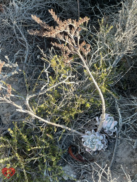
And there were some dried tall flower stalks arising from small rosettes of succulent leaves, which "Look Up" identified as Dudleya species.
Dudleya
After lunch, we saw expanses of grassy, rolling hills that make up much of the interior of Santa Rosa Island. While walking this stretch of trail, our naturalist pointed out the melodies of the western meadowlark. 

The east side of the Torrey Pines Loop Trail consisted of multiple switchbacks including some very steep segments.
Switchbacks coming down Torrey Pines Loop Trail
Thousands of the huge Torrey pine cones accumulated in the low areas at the bottom of numerous gullies, following the likely flow of rainwater.
Pine cones 
On the way back, we made sure to hit the Black Rock trail. Up among the Torrey Pines, we had tried to guess which rock gave its name to that peninsula. 
Black Rock
The deep green waters of the bay were so clear that it was easy to see strands of Giant Kelp waving among the waves.
Black Rock peninsula viewed from cliff over beach
My husband walked back to a fork in the trail that he has seen, and we took photos of each other from the two perspectives.
Cliff over beach viewed from Black Rock peninsula
And of course, we had to take the dusty road down to Water Canyon Beach.  As is traditional for us, whether at the coast of ocean or great lake, we made sure to get our hands in the water. 
Water Canyon Beach
Sand dune on Water Canyon Beach
Our naturalists indicated that we had made really good time on our hike, getting to the lunch spot by 11 am.  So a group of them wanted to return via the more difficult to follow Cherry Canyon Trail.

However, I really wanted to make sure I had time to visit the Schoolhouse, so we returned the way we came.

The tiny one-room schoolhouse had a door that was a bit sticky, so at first I thought it was locked. But I managed to get it open and found the NPS Passport Cancellation stamp set to the correct date.
In addition, there were photo exhibits lining the walls of the classroom.
After returning to the dock, we waited a few minutes for a Zodiac raft and returned to the ship.
Returning to the dock
I had just gotten to our room, which was on the same level as the exit to the rafts, when I heard them make the last call for a Zodiac tour. We had made such good time on the all-day hike that I was able to get the best of both worlds -- the long hike plus a raft tour! 
I was excited to see the northern part of Bechers Bay from the sea. Our naturalist showed us some examples of eelgrass and surfgrass. The blades are pristine when young, and then they progressively get crusted over.
Eelgrass
We saw thousands of pelicans perched on rocks between Corral Point and Coati Point. Many of them exhibited this interesting behavior of sticking their bills straight into the air and flapping the pouch around. Apparently, pelicans have their esophagus on one side, to protect it from the impact on the water, and they flap the pouch to the other side to keep it stretched out and flexible.
We were treated to a view of many pelicans taking off to sea, and rocks with both pelicans and sunbathing sea lions as we neared Carrington Point.
Sea lions near Carrington Point

Happy Hour, Dinner and Games

As the sun set over Santa Rosa Island, we enjoyed another fantastic Happy Hour.
Each evening, there was a complimentary cocktail of the day invented by the bar staff. The Foxy Lady was my favorite. In additional to the daily cheese, fruit and charcuterie spread, waitstaff brought around platters of finger foods that changed each day.
We enjoyed a recap of the day's underwater kelp forest video taken by the SCUBA team, with kelp perch instead of kelp bass seen in the waters of Bechers Bay. This was accompanied by a game of identify the bird sounds heard on the island: western meadowlark, raven, Anna's hummingbird, Bewick's wren, loggerhead shrikes and California towhees.
Roasted butternut squash soup with coconut milk & spiced cider; Pot-trapped Dungeness crab cake, Red wine braised Anderson Valley lamb shank, deconstructed carrot cake with cream cheese frosting

I highly enjoyed all the varied landscapes, plantlife and wildlife seen on this full day of hiking and rafting. As each grove of Torrey Pines (there are two on this island and one in La Jolla) are genetically identical, it's like three individuals isolated by distance from each other. Will these beautiful and endangered species survive into the future? 

Read about our hike to see the other subspecies of Torrey Pine located along the dramatic razor cliffs of La Jolla near San Diego in Torrey Pines State Natural Reserve. 

Click here for Los Angeles Area Eats and Hikes.
Click here for Day 1. Embarkation, Dolphins & Moonrise
Click here for Day 2a.  Anacapa Island Cliffs & Wildlife
Click here for Day 2b. Santa Cruz Island Fox & Hike
Click here for Day 4. Santa Catalina Two Harbors & Avalon


🍃 We were glad that the ship provided us with these beautiful Lindblad/National Geographic stainless steel water bottles to supplement the cool, science-themed ones we had brought. 18 oz of water would not have been enough.


What is your favorite island hike?

Please post comments below or photos to Instagram, Facebook or Twitter 

Tag @love2chowblog and hashtag it #love2chow 

All photos and content © 2023. 
All Rights Reserved. Contact admin@love2chow.com for permissions.


  • Share:

You Might Also Like

0 comments